New South Wales Projects
SOUTH COBAR POLYMETALLIC PROJECT
The South Cobar Project is located along the eastern margin of the Rast Trough at the southern end of the Cobar Basin. The project captures the northern and southern extensions of the Woorara fault, along strike from Eastern Metals’ (ASX: EMS) Brown’s Reef polymetallic deposit and the Achilles shear zone, hosting Australian Gold and Copper’s (ASX: AGC) Achilles 3 Polymetallic discovery [1].
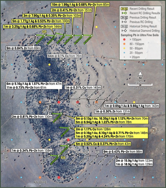
A 25-hole Reverse Circulation reconnaissance drill program (4,254m) was completed in September 2025 designed as three E-W traverses to test the relationship between the polymetallic soil anomaly, the prospective Achilles Shear and the intersecting NE-trending magnetic highs [2]. The drill program confirmed the fertility of the Achilles 1 Prospect with multiple intersections of polymetallic (Pb-Zn-Ag-Cu-Au) mineralisation. The program also identified secondary trends of mineralisation east of the outcropping hill which warrant further exploration and extensions of mineralisation north along the main structure.
These results have provided several immediate target areas to follow up. The next stage of exploration will include a detailed mapping program of the outcropping hill and a series of Induced Polarisation lines to identify blind chargeable sulfide-rich bodies at depth and beneath cover. SER is currently planning a follow-up exploration program at Achilles 1, as well as identifying additional targets within the South Cobar project area.
[1] ASX Announcement AGC 15th May 2024
[2] ASX Announcement SER 25th November 2024
MUNDI COPPER-GOLD PROJECT
The Mundi Project is a large-area, conceptual greenfield exploration project spanning over 1300km2 of the Curnamona Province, located approximately 115km NNW of Broken Hill. The Curnamona Province is a known iron oxide copper-gold (IOCG) mineral province with the potential for other mineral systems, such as Broken Hill Type Pb-Zn-Ag. The Project area has no known basement outcrop and very limited previous exploration.
The Mundi Project area targets the shallowest portion of the Curnamona Conductor (CC), a crustal-scale conductivity anomaly that has strong similarities to Magnetotelluric (MT) conductivity anomalies that have been interpreted to be associated with IOCG mineralisation in South Australia’s Gawler Craton
In November 2024 SER announced results from a Moving Loop Electromagnetic (MLEM) and Airborne Magnetic and Radiometric Survey (AMR) undertaken at Mundi to ground truth the previous MT modelling. Modelling has confirmed a significant conductive body at drillable depth that is associated with a remanent magnetic body. This is believed to be a new and unexplained relationship within the Curnamona Province and whilst there are numerous geological settings which could result in this relationship that include non-mineralised settings, intrusion related mineralised systems may also produce a similar response and therefore further exploration is warranted. Work is now underway to identify analogues in the Curnamona Province that share similar geophysical signatures to guide further exploration. Furthermore, given the project area contains multiple look-alike reversely magnetised bodies, future work will include additional ground EM and detailed drone magnetics over these prospects to model their depth and conductivity prior to target ranking and a future drill program.
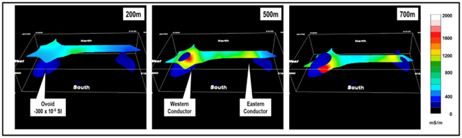
Above: 3D perspective view looking north showing MLEM conductivity depth slices for MT Line A2 relative to the modelled reversely magnetised ovoid (See ASX Announcement 16th December 2024)
WEST KOONENBERRY COPPER-NICKEL PROJECT
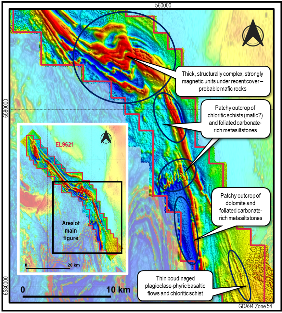
The West Koonenberry Project covers 483.5km2 of unexplored ground that SER interprets as the western extension of the Koonenberry Cu-Ni belt. The project is located approximately 100km NE of Broken Hill and adjacent to our Mundi Project.
SER interprets the linear magnetic rocks within the project area to be analogous to the Mount Arrowsmith mafic sills of the Koonenberry belt to the east, which is a highly prospective belt for Cu-Ni rich massive sulphides. The Koonenberry belt has previously been explored by INCO/Vale and IGO and is currently being explored by S2 Resources [1] (ASX:S2R). SER is targeting the equivalent mafic host rocks on the eastern edge of the Curnamona block, rifted from the Koonenberry belt during the formation of the Bancannia Trough. The Koonenberry belt is interpreted to be analogous to the Pechenga Copper-Nickel camp in Russia.
This year SER has completed and airborne magnetic survey across the entire tenement, secured land access and completed a reconnaissance field mapping trip at West Koonenberry. SER has also engaged CSIRO as part of a Kick-start Program that will access CSIRO research expertise to investigate the prospectivity of West Koonenberry to host a magmatic Ni-Cu-Co-PGE deposit. The objectives of the project are to confirm the presence of prospective geological units, particularly the hypothesised second belt of the Mt. Arrowsmith Volcanics, and map nickel-copper sulfide targets undercover [2].
[1] S2 Resources (ASX: S2R) Announcement October 2023
[2] SER Announcement September 2024